

A brief tornado warning has ended in Chatham-Kent.
UPDATE #3: The tornado warning has ended. A severe thunderstorm warning is now in place.
17:58 EnvCanada ended warning #Tornado #ChathamKent #ONStorm https://t.co/lXAMsG2Lab
— ChathamKent (@ECAlertON11) July 28, 2019
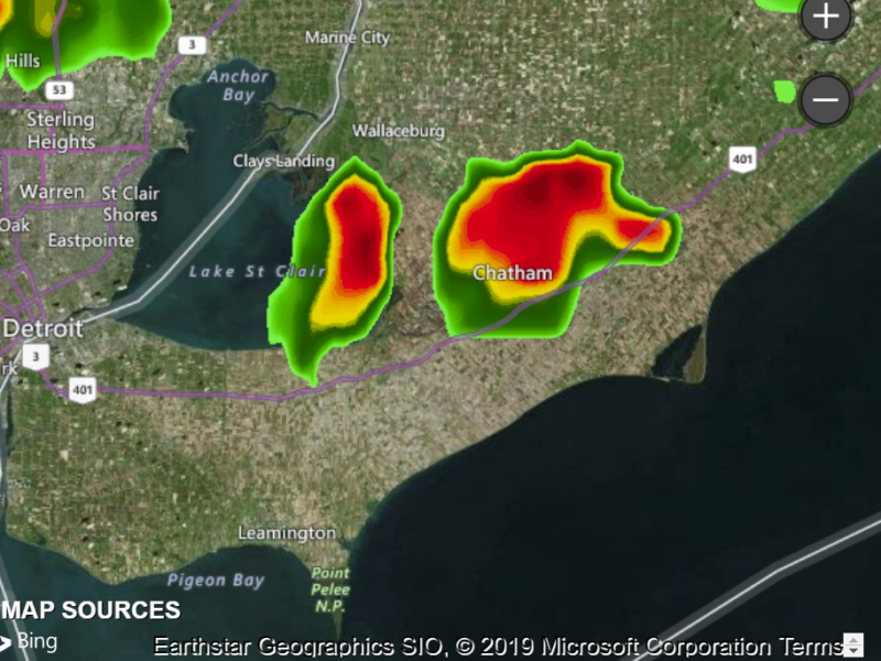
UPDATE#2: Here is a radar screen shot from 5:50 p.m., the storm is moving southeast.
UPDATE #1: At 5:44 p.m. EDT, Environment Canada meteorologists are tracking a severe thunderstorm that is possibly producing a tornado. Damaging winds, large hail and locally intense rainfall are also possible.
This dangerous thunderstorm is just northeast of Grande Pointe, moving east at 40 km/h.
This dangerous thunderstorm will be near:
Arkwood around 6:00 PM EDT.
Some locations which may be impacted include:
Arkwood, Oungah, Darrell, Eberts, Appledore, Thorncliffe, Louisville, Vosburg, Van Horne, Kent Bridge and Northwood.
A brief tornado is possible. Wind gusts to 100 km/h, torrential downpours giving 50 mm or more in an hour and frequent lightning are possible.
Take cover immediately, if threatening weather approaches. If you hear a roaring sound or see a funnel cloud, swirling debris near the ground, flying debris, or any threatening weather approaching, take shelter immediately. Lightning kills and injures Canadians every year. Remember, when thunder roars, go indoors!
Tornado warnings are issued when imminent or occurring thunderstorms are likely to produce or are producing tornadoes.
The Office of the Fire Marshal and Emergency Management recommends that you take cover immediately if threatening weather approaches.
Please continue to monitor alerts and forecasts issued by Environment Canada. To report severe weather, send an email to ONstorm@canada.ca or tweet reports using #ONStorm.
For more information: http://www.emergencymanagementontario.ca/english/beprepared/beprepared.html.
ORIGINAL STORY:
Details, here: At 5:36 p.m. EDT, Environment Canada meteorologists are tracking a severe thunderstorm that is possibly producing a tornado. Damaging winds, large hail and locally intense rainfall are also possible.
A severe thunderstorm near Pain Court may produce a brief tornado. Wind gusts to 100 km/h, torrential downpours giving 50 mm or more in an hour and frequent lightning are possible.
This thunderstorm is moving east at about 30 km/h.
Take cover immediately, if threatening weather approaches. If you hear a roaring sound or see a funnel cloud, swirling debris near the ground, flying debris, or any threatening weather approaching, take shelter immediately. Lightning kills and injures Canadians every year. Remember, when thunder roars, go indoors!
Tornado warnings are issued when imminent or occurring thunderstorms are likely to produce or are producing tornadoes.
The Office of the Fire Marshal and Emergency Management recommends that you take cover immediately if threatening weather approaches.
Please continue to monitor alerts and forecasts issued by Environment Canada. To report severe weather, send an email to ONstorm@canada.ca or tweet reports using #ONStorm.
For more information: http://www.emergencymanagementontario.ca/english/beprepared/beprepared.html.
This story will be updated.