

Update #7 at 4:14 p.m. – The severe thunderstorm warning has ended across Chatham-Kent, but the thunderstorm watch remains in place.
Update #6 at 3:57 p.m. – Mark Robinson from the Weather Network posted this tweet near Wallaceburg:
Wow! Looking good near Wallaceburg. Heading for Oil City now. @weathernetwork #ONStorm pic.twitter.com/qnDPbx6DBw
— Mark Robinson (@StormhunterTWN) July 10, 2020
Update #5 at 3:46 p.m. – The severe thunderstorm warning remains in effect across Chatham-Kent. Here are the details from Environment Canada:
At 3:46 p.m. EDT, Environment Canada meteorologists are tracking a line of severe thunderstorms capable of producing very strong wind gusts, pea to dime size hail and heavy rain.
This line of severe thunderstorms is located from Wallaceburg to 15 kilometres south of Port Alma, moving northeast at 45 km/h.
Locations impacted include:
Chatham, Wallaceburg, Blenheim, Rondeau Provincial Park, Ridgetown, Grande Pointe, Pain Court, Port Alma, Merlin, North Buxton, Dresden, Arkwood, Dealtown, Thamesville, Erieau and Morpeth.
Take cover immediately, if threatening weather approaches. Heavy downpours can cause flash floods and water pooling on roads. Strong wind gusts can toss loose objects, damage weak buildings, break branches off trees and overturn large vehicles. Lightning kills and injures Canadians every year. Remember, when thunder roars, go indoors!
The Office of the Fire Marshal and Emergency Management recommends that you take cover immediately if threatening weather approaches.
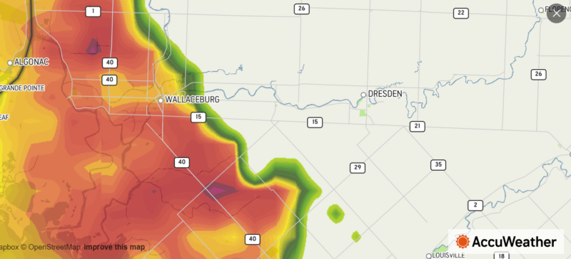
Update #4 at 3:45 p.m. – Here is a view of the radar from AccuWeather:
Update #3 at 3:24 p.m. – Entegrus is warning of potential downed power lines ahead of the approaching storm:
Severe Thunderstorms could impact parts of our service area today. High winds can bring down powerlines, please keep safety top of mind. If you see a downed powerline, keep a distance of at least 33 feet (the length of a school bus). https://t.co/LfOUVDwusk
— Entegrus Inc. (@Entegrus) July 10, 2020
Update #2 at 3:18 p.m. – A look at the radar from AccuWeather at 3:18 p.m. The system is moving toward Chatham-Kent.

Update #1 at 3:09 p.m. – A severe thunderstorm warning has now been issued across Chatham-Kent.
At 3:09 p.m. EDT, Environment Canada meteorologists are tracking a line of severe thunderstorms capable of producing very strong wind gusts, pea to dime size hail and heavy rain.
This line of severe thunderstorms is located from 20 kilometres southwest of Walpole Island to Point Pelee National Park, moving northeast at 50 km/h.
Locations impacted include:
Wheatley Provincial Park, Tilbury, Stoney Point, Comber, Elmdale, Wheatley, Lighthouse Cove, Mitchell’s Bay, Grande Pointe, Pain Court, Port Alma, Merlin and North Buxton.
Take cover immediately, if threatening weather approaches. Heavy downpours can cause flash floods and water pooling on roads. Strong wind gusts can toss loose objects, damage weak buildings, break branches off trees and overturn large vehicles. Lightning kills and injures Canadians every year. Remember, when thunder roars, go indoors!
The Office of the Fire Marshal and Emergency Management recommends that you take cover immediately if threatening weather approaches.
A severe thunderstorm watch has been issued across Chatham-Kent.
Here are the details from Environment Canada, issued at 10:51 a.m. – Conditions are favourable for the development of severe thunderstorms that may be capable of producing strong wind gusts and heavy rain.
These severe thunderstorms are forecast to develop this afternoon into this evening.
Lightning kills and injures Canadians every year. Remember, when thunder roars, go indoors!
Severe thunderstorm watches are issued when atmospheric conditions are favourable for the development of thunderstorms that could produce one or more of the following: large hail, damaging winds, torrential rainfall.
The Office of the Fire Marshal and Emergency Management recommends that you take cover immediately if threatening weather approaches.
Please continue to monitor alerts and forecasts issued by Environment Canada. To report severe weather, send an email to ONstorm@canada.ca or tweet reports using #ONStorm.
For more information: http://www.emergencymanagementontario.ca/english/beprepared/beprepared.html.
This story will be updated.