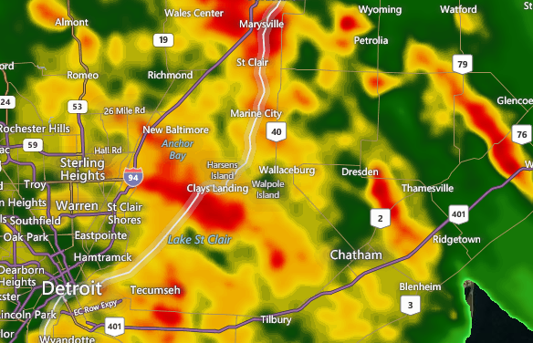
Updated at 9:25 p.m. by Environment Canada – The special weather statement for C-K ended.
Update from Environment Canada at 7:22 p.m. – Significant rainfall with isolated thunderstorms expected across the regions tonight.
An early fall type of low pressure system northern lower Michigan will track northeastward across Northern Lake Huron tonight then into Northeastern Ontario and Quebec by Thursday morning. This moisture laden low will drag a fairly sharp cold front across the regions tonight. Most regions will receive total rainfall amounts of 20 to 40 mm. However a few thunderstorms with very heavy downpours and gusty winds will be possible tonight resulting in local rainfall amounts near 50 mm. A Canwarn trained spotter measured about 75 mm of rain near Belle River in Essex County late Wednesday afternoon. A few wind gusts of 75 to 85 km/h are not out of the question over Southwestern Ontario this evening.
Motorists should be prepared for poor visibility and ponding of water on poorly drained sections of highways, resulting in difficult driving conditions.
The cold front will sweep out the moisture laden airmass overnight over Southwestern Ontario and early Thursday morning for remaining regions. Considerably cooler air will arrive in the wake of the cold front.
The public is advised to monitor future forecasts and warnings as warnings may be required or extended.
Updated by Environment Canada –
Conditions are favourable for the development of severe thunderstorms that may be capable of producing strong wind gusts and heavy rain.
There is potential for isolated thunderstorms to briefly become severe this evening. Torrential downpours and damaging winds are the main threats. An isolated tornado cannot be completely ruled out.
Fast moving water across a road can sweep a vehicle away. Strong wind gusts can toss loose objects, damage weak buildings, break branches off trees and overturn large vehicles. Remember, severe thunderstorms can produce tornadoes. Stay indoors when a thunderstorm strikes. There isn’t a place outside that is safe during a thunderstorm.
Emergency Management Ontario recommends that you take cover immediately, if threatening weather approaches.
Environment Canada meteorologists will update alerts as required, so stay tuned to your local media or Weatheradio. Email reports of severe weather to storm.ontario@ec.gc.ca or tweet with the hashtag #ONStorm.
Environment Canada has released an updated special weather statement at 2:02 p.m.:
Significant rainfall with isolated thunderstorms expected across the regions.
An early fall type of low pressure system over Wisconsin will track northeastward across Northern Lake Huron later today then into Northeastern Ontario and Quebec by Thursday morning. This moisture laden low is expected to drag a fairly sharp cold front across the regions tonight. Most regions will receive total rainfall amounts of 20 to 40 mm. However a few thunderstorms with very heavy downpours and gusty winds will be possible late today and tonight resulting in local rainfall amounts near 50 mm.
Showers, heavy at times, have already moved into the Windsor to Sarnia areas of Southwestern Ontario. They are expected to reach the Golden Horseshoe to Barrie and Muskoka regions between 4 and 6 PM then continue to spread northeast into remaining districts this evening.
Motorists should be prepared for poor visibility and ponding of water on poorly drained sections of highways, resulting in difficult driving conditions.
The cold front will sweep out the moisture laden airmass by Thursday morning and considerably cooler air will arrive in its wake.
The public is advised to monitor future forecasts and warnings as warnings may be required or extended.


