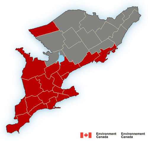
Updated at 5:21 p.m. – Very strong wind gusts that may cause damage are expected or occurring.
A low pressure system over Lake St. Clair will deepen quite quickly as it tracks north across Lake Huron tonighte then into Northeastern Ontario by Christmas Day. This low pressure area will blast a sharp cold front east across the regions tonight. Very strong southwesterly winds of 60 gusting to 90 km/h will herald the sudden arrival of this front. The very strong winds will continue for a few hours after the passage of the front, then very slowly ease off a little by Christmas morning. A few gusts of 100 km/h will be quite likely in exposed areas, in regions near the Great Lakes, and over higher ground as well.
Motorists travelling for the Christmas Holidays should be prepared for difficult driving conditions especially on highways exposed to strong and gusty cross winds.
These winds are also strong enough to cause some tree damage, may bring down tree limbs and some trees, and cause local power outages.
Damage to buildings, such as to roof shingles and windows, may occur. High winds may toss loose objects or cause tree branches to break. Be prepared to adjust your driving with changing road conditions due to high winds.
Wind warnings are issued when there is a significant risk of damaging winds.
Environment Canada meteorologists will update alerts as required, so stay tuned to your local media or Weatheradio. Email reports of severe weather to storm.ontario@ec.gc.ca or tweet with the hashtag #ONStorm.
Original story:
Environment Canada has issued a wind warning for Chatham-Kent, Sarnia-Lambton and much of southwestern Ontario for Christmas Eve.
Officials say very strong wind gusts that may cause damage are expected or occurring.
“A low pressure system over Western Kentucky will deepen quite quickly as it tracks north across Lake Huron on Christmas Eve then into Northeastern Ontario on Christmas Day, ” EC officials say.
“This low pressure area will blast a sharp cold front east across the regions tonight. Very strong southwesterly winds of 60 gusting to 90 km/h will herald the sudden arrival of this front tonight. The very strong winds will continue for a few hours after the passage of the front, then very slowly ease off a little by Christmas morning. A few gusts of 100 km/h will be quite likely in exposed areas, in regions near the Great Lakes, and over higher ground as well.”
Motorists travelling for the Christmas Holidays should be prepared for difficult driving conditions especially on highways exposed to strong and gusty cross winds, officials say.
These winds are also strong enough to cause some tree damage, may bring down tree limbs and some trees, and cause local power outages. Damage to buildings, such as to roof shingles and windows, may occur.
“High winds may toss loose objects or cause tree branches to break. Be prepared to adjust your driving with changing road conditions due to high winds,” EC officials say.