

Update #3: Severe thunderstorm warning ended for Chatham-Kent.
The rainfall warning remains in place.
Periods of rain, at times heavy, are expected tonight and Friday morning. Over some areas, isolated thunderstorm activity may be associated. Rainfall amounts will be variable, with average amounts in the 20 to 30 mm range. However 40 to 50 mm may be possible in some locales due to very heavy rainfall in thunderstorms.
Localized flooding in low-lying areas is possible. Don’t approach washouts near rivers, creeks and culverts.
Rainfall Warnings are issued when significant rainfall is expected.
Update #2: Updated or ended by 11:22 p.m. EDT.
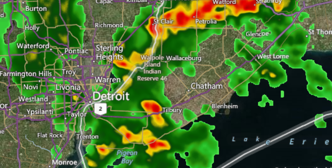
At 9:20 PM EDT, Environment Canada meteorologists are tracking several severe thunderstorms capable of producing very strong wind gusts, dime to nickel size hail and heavy rain. The thunderstorms are located near Wheatley and Chatham and are tracking northeastward.
Take cover immediately, if threatening weather approaches. Fast moving water across a road can sweep a vehicle away. Large hail can damage property and cause injury. Strong wind gusts can toss loose objects, damage weak buildings, break branches off trees and overturn large vehicles. Remember, severe thunderstorms can produce tornadoes. Go indoors and move away from windows and skylights. Avoid areas of the building that could be affected by falling debris such as tree limbs. Avoid driving through water on roads. Watch for possible washouts near rivers, creeks and culverts. In Canada, lightning kills up to 10 people every year. Remember, when thunder roars, go indoors.
The Office of the Fire Marshal and Emergency Management recommends that you take cover immediately, if threatening weather approaches.
Update #1: The Tornado watch has ended for Windsor, Leamington and Essex County.
However, a severe thunderstorm warning is in effect for Chatham-Kent.
Persons in or near this area should be on the lookout for adverse weather conditions and take necessary safety precautions. Watch for updated statements.
Original story: Environment Canada has issued a Tornado watch for Windsor, Leamington and Essex County.
A rainfall warning continues in Chatham-Kent.
A severe thunderstorm warning is in effect in Sarnia-Lambton.
Conditions are favourable for the development of severe thunderstorms which may produce tornadoes, Environment Canada officials said about Windsor, Leamington, Essex.
Severe thunderstorms have developed over Lower Michigan and are likely to track into Ontario.
The threat of severe thunderstorms should end late this evening.
Be prepared for severe weather.
Take cover immediately, if threatening weather approaches.
In the event of a tornado, or if a tornado warning is issued for your area, it is recommended you take the following actions: Go indoors to a room on the lowest floor, away from outside walls and windows, such as a basement, bathroom, stairwell or interior closet.
Leave mobile homes, vehicles, tents, trailers and other temporary or free-standing shelter, and move to a strong building if you can.
As a last resort, lie in a low spot and protect your head from flying debris.
The Office of the Fire Marshal and Emergency Management recommends that you take cover immediately, if threatening weather approaches.
Environment Canada meteorologists will update alerts as required, so stay tuned to your local media or Weatheradio. Email reports of severe weather to storm.ontario@ec.gc.ca or tweet with the hashtag #ONStorm.