
The Lower Thames Valley Conservation Authority (LTVCA) has issued a flood watch, as heavy rainfall is expected to hit the region starting today.
Jason Wintermute, water management supervisor, said the Thames River watershed has received 30 to 50 mm of rainfall over the past week, with the majority of that occurring Sunday and Monday.
“Environment Canada has issued a Rainfall Warning, noting that 40 to 70 mm of rain can be expected Thursday through Saturday and that there is a possibility of localized flooding due to the heavy rains,” Wintermute said in a press release.
“Generally rainfall forecasts are calling for 25-50 mm of rainfall tomorrow and 20-40 on Friday.”
Wintermute said local watercourses are running higher than usual due to the recent wet weather.
“The ground is already wet and can’t absorb much more rainfall, so much of the upcoming rainfall can be expected to run off into the local watercourses,” he said.
“Even with the lower predicted rainfall amounts, local watercourse would be expected to rise and some would spill their banks. The Lower Thames Valley Conservation Authority expects to be operating the Indian-McGregor Creek Diversion Channel to protect the south end of the City of Chatham from flooding.”
Wintermute said the Thames River itself is still running high from the rainfall on Sunday and Monday.
“The Thames has peaked around Dutton from that rainfall event and should peak in Thamesville overnight (on Wednesday)and around noon (on Thursday) in Chatham. However, because of how wet it is, water levels on the Thames are falling quite slowly. This means that the Thames River will still be up from the last rainfall event when it gets this new rain (today).”
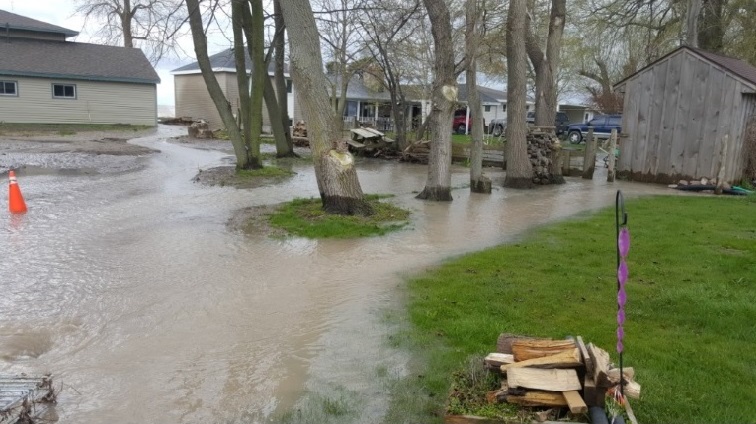
He said water levels on the Thames will rise from the rain and should be expected to flood the river flats from Delaware to Chatham.
“If the higher predicted rainfall amounts appear, the Lower Thames Valley Conservation Authority may have to operate the 6th Street Backwater Dam and Pumping Station in downtown Chatham to prevent the Thames River from flooding back up McGregor Creek,” he said.
“The Thames River should be expected remain high into the middle of next week.”
Residents along the Lake Erie shoreline should also take precautions, Wintermute added.
“In addition to the heavy rains, sustained winds of 35 km/hr gusting to 55 km/hr out of the east are predicted for (Thursday) afternoon and into Friday morning,” he said.
“These predicted winds are only slightly less intense than what caused flooding along Erie Shore Drive in Chatham-Kent (on Tuesday). However, sustained winds from the east have the potential to raise lake levels in the region and to aggravate the situation. There is a risk that wave action could damage shoreline protection works and cause shoreline erosion, especially in those locations already compromised by (Tuesday’s) event.”
Wintermute added: “People should take extra caution and avoid the shoreline, river, ditches, and streams. The combination of slippery banks and fast moving cold water can be dangerous. Standing water can also present its own unseen hazards. Children, pets and livestock should be kept away from the water.”
LTVCA officials will continue to monitor the situation and update this advisory if necessary.
This flood watch will be in effect until May 10.
Officials with the St. Clair Region Conservation Authority has yet to issue any notices about the Sydenham River.
Watch for more updates on the Sydenham Current.