

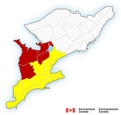
A tornado watch has been issued in Chatham-Kent.
Conditions are favourable for the development of severe thunderstorms which may produce tornadoes.
Severe thunderstorms will race across the regions tonight. There is some potential for isolated tornadoes. In addition torrential downpours, damaging winds, intense lightning and hail are possible.
Be prepared for severe weather. Take cover immediately, if threatening weather approaches.
In the event of a tornado, or if a tornado warning is issued for your area, it is recommended you take the following actions: Go indoors to a room on the lowest floor, away from outside walls and windows, such as a basement, bathroom, stairwell or interior closet. Leave mobile homes, vehicles, tents, trailers and other temporary or free-standing shelter, and move to a strong building if you can. As a last resort, lie in a low spot and protect your head from flying debris.
The Office of the Fire Marshal and Emergency Management recommends that you take cover immediately, if threatening weather approaches.
Environment Canada meteorologists will update alerts as required. Please monitor local media or Weatheradio. To report severe weather, send an email to storm.ontario@ec.gc.ca or tweet reports to #ONStorm.
Environment Canada has also issued a special weather statement:
Strong thunderstorms likely later tonight.
A line of thunderstorms over Michigan is moving east and may affect the regions from Windsor to Niagara later tonight.
Some of the thunderstorms will contain frequent lightning, wind gusts to 85 km/h, and very heavy downpours as they move through.
There is potential for some of the thunderstorms to become severe later tonight, and watches in effect for areas to the north and west may be expanded into the regions later tonight as required.
Environment Canada is closely monitoring this situation.
The public is advised to monitor future forecasts and warnings as warnings may be required or extended.