Update #5: Here is a snap shot of the radar from AccuWeather at 12:44 a.m. on Saturday, June 27, 2020:
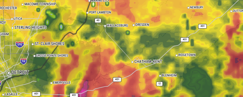
The LIVE radar can be seen, here.
The latest information from Environment Canada can be seen, here.
Update #4: A severe thunderstorm warning remains in effect in Chatham-Kent. Here is the latest from Environment Canada:
At 12:08 a.m. EDT, Environment Canada meteorologists are tracking an area of dangerous thunderstorms capable of producing very strong wind gusts and flooding rain.
Hazards:
– Wind gusts to 90 km/h.
– Rainfall amounts in excess of 50 mm could lead to flash flooding.
– Risk of a tornado.
Locations impacted include:
Areas south and east of Lake St. Clair.
A large area of thunderstorms is moving east at 60 km/h over the area. Heavy rain is expected with these thunderstorms with some areas possibly receiving 75 mm before thunderstorms move east of the area overnight.
Take cover immediately, if threatening weather approaches. Heavy downpours can cause flash floods and water pooling on roads. Remember, severe thunderstorms can produce tornadoes. Avoid driving through water on roads.
Severe thunderstorm warnings are issued when imminent or occurring thunderstorms are likely to produce or are producing one or more of the following: large hail, damaging winds, torrential rainfall.
The Office of the Fire Marshal and Emergency Management recommends that you take cover immediately if threatening weather approaches.
Please continue to monitor alerts and forecasts issued by Environment Canada. To report severe weather, send an email to ONstorm@canada.ca or tweet reports using #ONStorm.
For more information: http://www.emergencymanagementontario.ca/english/beprepared/beprepared.html.
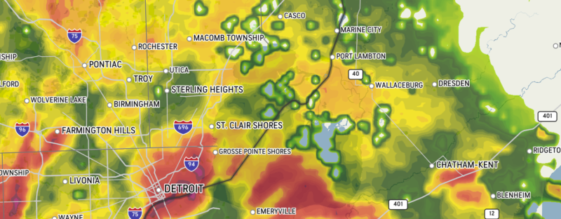
Update #3: Here is a snapshot of the radar from AccuWeather at 11:55 p.m. A severe thunderstorm warning remains in effect.
Update #2: At 10:54 p.m. EDT, Environment Canada meteorologists are tracking an area of dangerous thunderstorms capable of producing very strong wind gusts and flooding rain.
Hazards:
– Wind gusts to 90 km/h.
– Rainfall amounts in excess of 50 mm could lead to flash flooding.
– Risk of a tornado.
Locations impacted include:
Areas south of a line from Lake St. Clair to Chatham-Kent.
A large area of thunderstorms over Michigan extending over the Windsor area are moving into the area. Heavy rain is expected with these thunderstorms with some areas possibly receiving 75 mm before thunderstorms move east of the area overnight.
Take cover immediately, if threatening weather approaches. Heavy downpours can cause flash floods and water pooling on roads. Remember, severe thunderstorms can produce tornadoes. Avoid driving through water on roads.
Severe thunderstorm warnings are issued when imminent or occurring thunderstorms are likely to produce or are producing one or more of the following: large hail, damaging winds, torrential rainfall.
The Office of the Fire Marshal and Emergency Management recommends that you take cover immediately if threatening weather approaches.
Please continue to monitor alerts and forecasts issued by Environment Canada. To report severe weather, send an email to ONstorm@canada.ca or tweet reports using #ONStorm.
For more information: http://www.emergencymanagementontario.ca/english/beprepared/beprepared.html.
Update #1: A severe thunderstorm warning has been issued in Chatham-Kent. Watch for more details.
Environment Canada has issued a severe thunderstorm watch across Chatham-Kent, as conditions are favourable for the development of dangerous thunderstorms that may be capable of producing damaging wind gusts and torrential rain.
Forecasters say some of the hazards, include:
– Wind gusts to 100 km/h.
– Torrential downpours leading to flash flooding.
– Risk of a tornado.
The timing of the storm is late this evening and overnight as thunderstorms over Michigan are expected to move into the area.
“Fast-moving water across a road can sweep a vehicle away,” Environment Canada officials say.
“Very strong wind gusts can damage buildings, down trees and blow large vehicles off the road. Heavy downpours can cause flash floods and water pooling on roads. Lightning kills and injures Canadians every year. Remember, when thunder roars, go indoors.”
Severe thunderstorm watches are issued when atmospheric conditions are favourable for the development of thunderstorms that could produce one or more of the following: large hail, damaging winds, torrential rainfall.
The Office of the Fire Marshal and Emergency Management recommends that you take cover immediately if threatening weather approaches.
Please continue to monitor alerts and forecasts issued by Environment Canada.
To report severe weather, send an email to ONstorm@canada.ca or tweet reports using #ONStorm.
For more information: http://www.emergencymanagementontario.ca/english/beprepared/beprepared.html.